

WSIL �� A really nice morning outside with temperatures in the upper 50s across southern Illinois.
Sunshine is expected this morning, but as a cold front approaches the region later this afternoon, clouds will begin to build back in. Ahead of this front, it will be notably more humid with high temps in the lower 80s
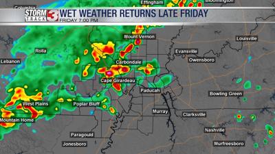
A few isolated storms may develop as early as 4 p.m., but most of the wet weather holds off until later this evening. Widespread showers & a few storms are expected to sweep across the region. The severe storm risk is low, but heavy downpours & lightning is possible with the strongest storms.
By daybreak Saturday, rain will be exiting to the south, with cooler, less humid air filtering in from the north. There will be tons of sunshine Saturday, but high temperatures will be running below average, only peaking in the lower 70s.
Sunday will be a little warmer with highs in the upper 70s.
A long stretch of dry weather is likely through next week, with summer-like warm & humid air gradually moving back in.