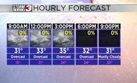


WSIL(Carterville, Ill.) -- This morning, we are tracking temperatures that are near freezing for most of us in southern Illinois, while temperatures are still lingering the in the lower 40s further east, ahead an approaching cold front.
For today, you can expect to see the cold front clear the region by 7 or 8 this morning. In its wake, we are tracking temperatures that will linger in the lower to mid 30s through most of the day. But, winds will make it feel colder; winds will be sustained out of the northwest at 15 to 20 miles per hour, with gusts potentially as high as 30 to 35 miles per hour. Skies all day today will remain overcast in southern Illinois, though a few locations in southeastern Missouri could see some clearing skies late. Despite the cloud cover, we are tracking mostly dry conditions other than just a few snow flurries in our eastern counties.
Overnight, we will see skies clear, as high pressure returns to the region. This will help morning lows tomorrow reach the lower to mid 20s. Wind chill values tomorrow morning could be in the lower 20s and teens to kick off Saturday. For the afternoon, we are tracking mostly sunny skies, with temperatures that will reach the upper 30s for afternoon highs. Winds tomorrow will be fairly light, so wind chills should be fairly close to the actual air temperature.
Sunshine sticks around for Sunday as well, and highs should be slightly warmer, in the lower to mid 40s. A big warm up is expected to kick off next week, with temperatures expected to reach the upper 40s for Monday and the 50s for Tuesday and Wednesday. With warmer temperatures, we are tracking increasing rain and storm chances next week.