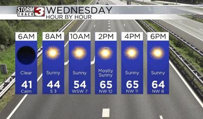


WSIL(Carterville, Ill.) -- This morning, most of us are waking up to temperatures in the lower 40s and a few isolated locations have dropped into the upper 30s across southern Illinois. Skies this morning are mostly clear with light winds.
Today, you can expect to see sunshine last all day today, other than a few upper level, fair weather clouds this afternoon. Temperatures by midday should each the upper 50s to lower 60s, and highs today will be very similar to yesterday. Most locations are expected to reach the upper 60s to lower 70s for highs, with the warmest conditions expected to be over southeastern Missouri once again. Given how dry the air will be, there is an Elevated Risk for fire this afternoon. Winds today will be a little bit breezy, out of the northwest at 10 to 15 miles per hour.
This evening, temperatures will be warm, with most spots expected to hang on to the mid 60s still through 7 PM, with clear skies. After sunset, we are tracking skies that will turn mostly cloudy. After midnight, we are tracking the potential for isolated to scattered showers and a few rumbles of thunder. These showers should remain highly concentrated to southern Illinois. Showers and storms are expected to persist through the morning hours tomorrow, but then dry conditions are expected by 9.
Temperatures for morning lows tomorrow will be in the mid 40s, with highs in the mid to upper 60s. We also could see a few chances for isolated storms layer on tomorrow afternoon. Another round of isolated showers and storms are possible Friday afternoon, but the better chances for rain and storms will hold off until the weekend. Sunday will certainly be a day to watch in terms of severe weather, as the entire region is included in an area of concern for severe weather.
Highs Friday through the weekend will be in the mid to upper 70s.