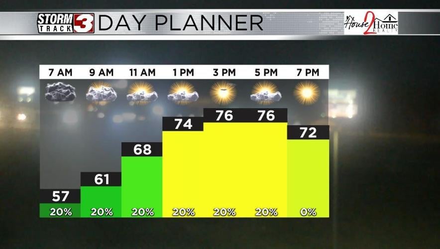


WSIL(Carterville, Ill.) -- This morning, we are waking up under mostly cloudy skies, with temperatures for most of us that are running in the upper low to mid 50s. We are also seeing isolated to scattered showers and thunderstorms mainly in our southern counties.
For today, we are tracking temperatures that will be in the mid to upper 70s for highs, much like we saw yesterday, and have seen over the last several days. Morning clouds will give way to partly cloudy skies this afternoon. We will see a few scattered showers and thunderstorms linger across the area through the midday hours. Things will mostly dry out for the afternoon, but another chance of a couple of isolated storms will reenter the region after 3PM this evening. Nothing severe is expected today, but Friday is expected to be quite dicey in terms of severe weather.
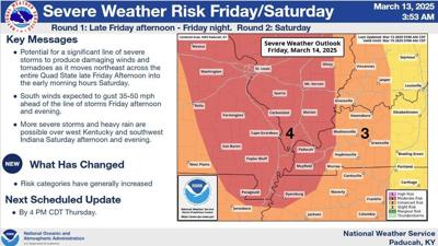
Most of the day will be partly cloudy to mostly sunny. After 6PM, however, we will start to see scattered showers and thunderstorms push into our far western counties in southeastern Missouri. Thunderstorms will gradually become more widespread through the evening and overnight hours. Storms are expected to enter far western Illinois between 9 and 11 PM and exit the region, entirely, sometime between midnight and 2AM. Overall, there is a level 3 enhanced risk of severe weather for Friday, for the entire area. The primary hazards with these storms will be damaging winds, and tornadoes. One limiting factor that may help storms not be as strong is the lack luster amounts of moisture at the surface. However, the potential is still there.
Friday morning lows will be in the mid 50s, with highs in the upper 70s to near 80 for most of us.
The National Weather Service upgrades us at a Level 4 risk for severe storms. The timing of which will be Friday evening starting in the southeast Missouri area, 9 p.m. to 2 a.m. for the southern Illinois area, and early morning hours for western Kentucky.
A few storms may linger Saturday, especially if the cook front slows down. Temperatures will be in the upper 60s to low 70s for highs. Cooler weather is expected for Sunday.