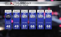


WSIL(Carterville, Ill.) -- This morning, we are tracking temperatures that are in the mid to upper 40s across most of the region with mostly cloudy skies. We are seeing more sunshine further south and west in southeastern Missouri. We are also seeing a couple of isolated showers mainly in the north and eastern parts of the viewing area.
For today, showers will stick around through most of the morning, likely winding down after 10 or 11 this morning, however. If you do manage to run into one of these showers, they will be very brief, and a wash out is not expected. Temperatures by midday today will reach the low to mid 60s, and highs will reach the low to mid 70s for afternoon highs. Skies through the mid morning and early afternoon will be partly to mostly cloudy. Further south and west in southeastern Missouri, we are tracking mostly sunny skies, with temperatures that should reach the mid to upper 70s for high temperatures.
Another chance of isolated thunderstorms is expected this afternoon and evening, mainly in the northern and eastern areas of the viewing area. Nothing severe is expected and we will see these showers move in after 3 or 4 this afternoon and wind down after 9 or 10 this evening. This chance for storms will once again remain isolated.
Isolated to scattered showers and thunderstorms will be possible on Friday afternoon once again, but better rain chances will hold off until the weekend. Sunday is certainly a day to watch across the area as we are highlighted in an area of concern for severe weather Sunday afternoon. While this is not a guarantee of severe weather, it is certainly something to remain aware of.
Temperatures for tomorrow morning will be in the low 60s across the area and highs will reach the low to mid 70s, and potentially the upper 70s if we can get enough sunshine! Warmer conditions are expected for the weekend as well with highs running into the upper 60s to mid 70s for both Saturday and Sunday.