
WSIL(Carterville, Ill.)-- This morning, most of us are waking up to temperatures in the upper 60s and lower 70s. We are seeing dew points close to the actual temperatures, so we could see some isolated areas of patchy fog this morning.
Any patchy fog should burn off quickly with the sunshine. It is going to be quite hot today; we are tracking temperatures that by midday that will be in the upper 80s and lower 90s. Highs today will be in the low to mid 90s for most of us. Heat index values will be in the lower 100s.
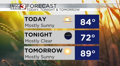
Skies today will be mostly sunny all day, and we will see clear skies overnight tonight.
Morning lows tomorrow will be in the lower 70s, and highs will warm into the mid to upper 90s for most of us. Heat index values will will be in the low to mid 100s tomorrow afternoon, likely between 100 and 105.
We are tracking a dry cold front that that will move through late Tuesday evening, and we will see see cooler highs behind the front, with highs only in the mid 80s.
Dry and mostly sunny skies are expected all week.