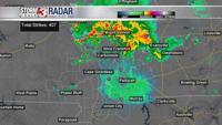


WSIL (Carterville) -- We're kicking off midweek with shower and storm chances mostly across southern Illinois and a few isolated showers in southeastern Missouri.
These storms are loud as they move through with lots of thunder and lightning. There are pockets of heavy rain as well which could slow down your morning commute.

The severe risk does stick around with our eastern counties seeing a Slight (2 out of 5) threat. Areas a bit further west are seeing a Marginal (1 out of 5) threat.

Areas seeing a bit more rain this morning will stay cooler in the upper 70s, but most of us will be back in the mid 80s again. We see a bit of a lull in rain around lunchtime, but the chance will pick back up by this evening and overnight.

If you're like me and you're trying to hunt down those cooler, fall temperatures... they won't be coming around anytime soon. We stay in the mid 80s for at least another week.