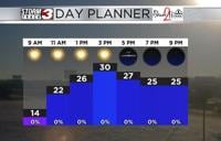


WSIL (Carterville, Ill.) -- This morning, we are tracking temperatures that are in the mid to upper 40s to lower 50s across most of southern Illinois, with the lower 60s further south across western Kentucky and southeastern Missouri. Where we are seeing the warmer temperatures, we are tracking patchy to dense fog, with visibility being reduced to as low as a quarter mile in some spots. For this, we are tracking a dense fog advisory for the bootheel of Missouri until 10 this morning.
In addition to the dense fog, we are also tracking isolated showers that are exiting the region to our east, but a few light showers are lingering in southern Illinois. As we go through the day, we are tracking a cold front that will slowly push through the region. This will cause a few isolated to scattered showers to from, but showers are expected to be light and of the hit and miss variety.
This cold front will cause temperatures to cool across southern Illinois through the afternoon with temperatures expected to be in the low to mid 40s. Further south across southeastern Missouri and Western Kentucky, we could see temperatures linger in the mid to upper 50s through the early afternoon hours. A few isolated showers are possible through the evening, but we should dry out in the overnight hours.
Overnight, we will see louds clear across southern Illinois. This will help temperatures cool into the lower 30s to kick off our Friday. Temperatures tomorrow will only be in the lower to mid 40s for afternoon highs.Cloud cover will build back into the region in the afternoon, but we should remain mostly dry. But, a few isolated showers are possible late Friday evening.
Better shower and storm chances return for Saturday. Yet another cold front will push through on Sunday, and will provide much colder temperatures for Sunday and early next week.