
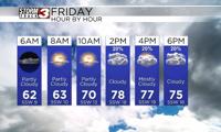


WSIL(Carterville, Ill.) -- This morning, we are tracking temperatures that are in the lower 60s and upper 50s. We are seeing partly cloudy skies for most of us here in southern Illinois. We are seeing a little less cloud cover further south in southeastern Missouri and western Kentucky.
Today, you can expect to see a mix of sun and clouds, with temperatures that will reach the mid 70s by the midday hours. More clouds cover is expected for the afternoon, but this will not inhibit temperatures from warming up. Highs today will reach the upper 70s to lower 80s across the entire area. These warmer temperatures will be assisted by winds that will be breezy winds, that will be out of the southwest at 10 to 20 miles per hour, with gusts that could be as high as 30 miles per hour.
Mostly cloudy to overcast skies are expected for the evening hour tonight. Temperatures should stay warm, in the lower 70s through 7 or 8 this evening. Isolated showers are possible between 5 PM and Midnight this evening. These showers should remain over southeastern through most of the evening, but after midnight, widespread rain and storms are expected.
For tomorrow, we tracking widespread rain and storms. They will be off and on, at times, but overall coverage will remain fairly widespread. This pattern will continue on Sunday. Sunday is definitely a day to remain weather aware, as the entire region is in a level 3 out of 5 severe weather risk. The primary hazard does look to be large hail. However, large tornadoes and damaging winds will also be of concern.

Temperatures for tomorrow morning low will be in the lower 60s, with highs in the upper 60s to lower 70s. Highs for Sunday will be much warmer, likely in the upper 70s to near 80.