

WSIL(Carterville, Ill)-- This morning, we are waking up to a little bit of patchy fog across our southern and western counties, especially near the Ohio and Mississippi Rivers. Fog will not stick around for the entire day; it will burn off once the sun comes up at around 7:10 this morning.
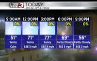
All day today, we will see lots of sunshine. Temperatures will warm into the lower 50s by the 9 o'clock hour and into the mid 60s by the midday hours. Highs today will be in the mid to upper 70s. Despite above average temperatures, humidity levels will remain very comfortable.
Temperatures will return to the 60s as we get into the evening, and we could see a few passing clouds early, but then, mostly clear skies will be with us through the overnight hours.
Morning lows tomorrow will be in the upper 40s and lower 50s for most of us. Skies tomorrow, we will be mostly sunny, but during the midday hours, we could see a few brief isolated showers.
Highs tomorrow will warm into the mid to upper 70s once again. The mid to upper 70s are expected for Wednesday, but a cold front will push through the region Wednesday. The lower 70s are expected Thursday, and another cold front should move through Friday. A few isolated showers are possible Friday afternoon, but the most notable impact from the cold front will be the change in temperatures; we will only see highs in the mid 60s for Saturday and Sunday.