


WSIL(Carterville, Ill.) -- This evening, we are tracking temperatures that are extremely warm, with most places reporting the upper 70s to lower 80s. Some locations in the bootheel are reporting temperatures in the mid 80s! While we did see lots of sunshine earlier today, skies have since turned mostly cloudy to overcast this evening. Winds are also on the strongside, out of the southwest at 10 to 20 miles per hour.
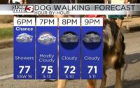
Tonight, we will still see temperatures remain in the mid 70s through 7PM and the dip into the upper 60s by 11PM. Through the evening, winds will be out of the south at 10 to 20 miles per hour. A few isolated showers and thunderstorms are possible through midnight, so if you do have any outdoor plans this evening, make sure to grab an umbrella. This evening will not be a washout.
Rain chances for tomorrow will be scattered to widespread, especially after 6 AM. Widespread rain will be with us though most of the day tomorrow, likely not winding down until after 6 or 7 in the evening. There could be a lull in the shower activity overnight through Sunday morning. Sunday is definitely a day to remain weather aware.
The entire region is in an enhanced level 3 out of 5 severe weather risk for Sunday afternoon. We are monitoring the potential for strong to severe storms to form between 4 PM and 2 AM. As of right now, we expect supercell thunderstorms to form in the afternoon and evening, with the primary hazards being extremely large hail and tornadoes. One thing that may end up being a limiting factor for these supercells will be a strong cap in the atmosphere.
We expect the cap to break down as we head into the late evening. This will be associated with a cold front, and long it, we expect a line of storms form and track through the region. Damaging winds and a few tornadoes are possible with the line.
Temperatures tomorrow morning will be in the low to mid 60s, and temperatures will remain fairly constant through the day. Sunday will be much warmer, with highs expected to be in the upper 70s, perhaps even warmer if we can get more sunshine.