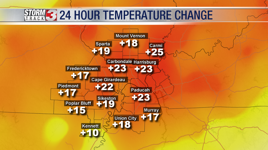

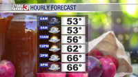


WSIL (Carterville, IL)-- Today, most of us are waking up to temperatures are into the mid to upper 50s. Some spots, mainly across southern Illinois are 20 to 25 degrees warmer than this time yesterday.

This morning, skies will be partly to mostly cloudy, and a few isolated showers are possible. Temperature wise, most areas will be in the upper 50s to low 60s by mid morning, and cloud cover will be increasing. We will lose the isolated shower chance as the morning progresses, though a few sprinkles could linger. A weak cold front will move through the area through the morning. However, it will have little impact on highs, rain chances, and cloud cover this afternoon.
We are tracking temperatures that, by lunchtime, will be in the low to mid 60s with mostly cloudy skies. The afternoon should be dry, despite the cloud cover. Temperatures this afternoon should get into the mid to upper 60s.
This evening, we are tracking temperatures that will fall into the mid to upper 50s by 6 PM, and into the upper 40s by midnight. The chance of an isolated shower will return for the late evening and into the overnight hours behind the cold front.

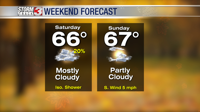
Tomorrow will be cooler in the morning, with overnight lows in the low to mid 40s. We are tracking mostly sunny skies for the morning. We will remain mostly dry tomorrow, though a few showers are possible, especially in the early, pre-dawn, hours. Tomorrow afternoon, we are tracking highs that will again be in the mid to upper 60s, with partly cloudy skies.
Looking ahead to next week, we are tracking above average temperatures through Wednesday, as well as increased rain chances for late week.