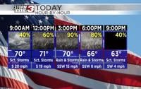


WSIL(Carterville, Ill) -- This morning, most of us are waking up to temperatures that are very warm with most locations seeing temperatures in the upper 60s and lower 70s. Winds are also quite strong, out of the south-southeast, at 15-20 miles per hour. Additionally, most of us are waking up to mostly dry conditions, but showers and storms are just west of the region.
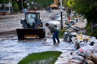
Today, you can expect to see widespread showers and thunderstorms. These showers and storms will move from west to east across the area. We will see showers and storms enter our western counties, mainly in southeastern Missouri around 6 to 7AM. Slowly, we will see the cold front push them east through the region. They will enter western Illinois by the midday hours, and the best chances for widespread rain and storms will be between noon and 5PM for southern Illinois, and after 5PM we should see shower chances turn a little more scattered isolated We will see widespread showers last likely through 8 or 9PM in our eastern counties. After 9PM shower chances should become a little more isolated. Shower chances will not completely each zero until the cold front passes late this evening.
Winds today will continue to be fairly breezy this afternoon with sustained winds of 20 to 25 miles per hour, gusting up to 35 miles per hour. Highs will be around the lower to mid 70s for most of us today as well. But, behind the cold front, we will see temperatures drop into the lower to mid 50s tomorrow morning. Highs tomorrow will only reach the mid 60s.
We will see isolated showers for Thursday and Friday, but better rain chances will arrive for the weekend, with a 60 percent chance expected for Saturday and a 40 percent chance for Sunday.