


WSIL(Carterville, IL)--Currently, we are tracking sunny skies and temperatures that are in the mid to upper 50s, and a few isolates spots have made it to the low 60s, mainly in far southeastern Missouri. Winds are also mostly calm, with only a few spots reporting gusts of 5 to 7 miles per hour. These mild conditions are due to an area of high pressure that is centered almost directly on top of our region.
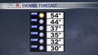
As afternoon turns to evening, we are tracking temperatures that will be in the upper 40s by 6:00 PM. Skies will be clear, and should be remaining clear by the time we make it to midnight. Winds will be mostly calm during the first half of the evening, but will increase slightly to be out of the southwest at about 4 to 5 miles per hour.

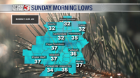
Temperatures will likely make it to the mid to upper 30s, and continue to drop through the overnight hours. Morning lows should make it to near freezing tomorrow morning in southern Illinois, and a few spots could drop to the freezing mark or slightly below freezing. Winds tomorrow will be variable at about 4 miles per hour, with partly cloudy skies.

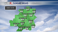
As the morning progresses, cloud cover will gradually increase, and become mostly cloudy later in the day. This, however, will not inhibit temperatures from quickly rebounding into the mid 50s by lunchtime, and we are tracking similar highs to today in the upper 50s and low 60s for tomorrow afternoon.
There is a chance of a stray shower tomorrow afternoon across southeastern Missouri and far western Illinois. But, most of us will remain dry. As we go into the overnight, rain chances will go up ahead of a system that will being increased rain chances.
To start the work week, temperatures will be near or slightly above average due to a warm front lifting across the area. With the warm front, we are tracking increased rain chances for Monday and Tuesday. Monday will likely have the greatest potential for rainfall. A cold front will move through the area, and cool our temperatures by midweek.