
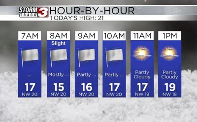


WSIL(Carterville, IL)--Overall, this morning we are tracking mostly cloudy skies. A few light snow showers are possible early this morning. There is still a a Winter Weather Advisory in effect for western Kentucky, the bootheel of Missouri, and northwest Tennessee until 9:00 this morning due to the possibility of additional freezing drizzle, fog, and light snow accumulations through the early morning hours. No significant accumulations are expected. However, it will not take much freezing drizzle to cause travel headaches for the morning commute, especially in western Kentucky.
Overall today, skies that will be mostly cloudy this morning and before we see partly cloudy skies this afternoon. Despite the clouds clearing in the afternoon, we will not see temperatures warm this afternoon.
This is due to an artic cold front that will push through the area this morning, and temperatures will drop gradually though the day. For this reason, there is a Wind Chill Advisory in effect for most of the region from 9:00 PM this evening through 9:00 AM tomorrow morning. We could see wind chills once again as low as -10, especially early tomorrow morning.
Cold artic air will linger tomorrow with highs tomorrow in the teens and lower 20s. We will see slightly warmer weather for Sunday, before temperatures warm significantly next week. We will also see plenty of chances for rain next week.