


WSIL(Carterville, IL)-- This morning, a lot of us are waking up to temperatures in the 60s in southern parts of the region, and most of us in the low to mid 50s in our northern counties where a cold front is pushing through.Â
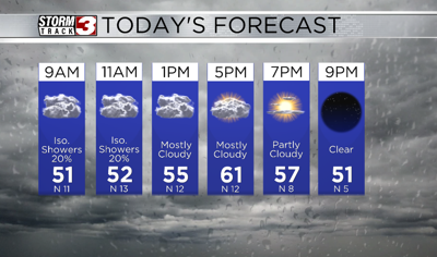
We are still seeing a few rain showers across western Kentucky and northwestern Tennessee, but there is no severe weather expected. We will see rain chances decrease through the morning and they will not be returning anytime soon. Â
Today, you can expect to see mostly cloudy skies with temperatures that will be in the low 50s this afternoon. Skies will be mostly cloudy though the afternoon with temperatures in the mid to upper 50s.Â
Clearing skies can be expected through the overnight hours, and they will be mostly sunny to start the day tomorrow, before turning partly cloudy in the afternoon.Â
Highs tomorrow will be in the mid to upper 60s.Â
A cold front will push through Sunday and being us highs in the 50s. This front will not bring any chances for rain, but colder weather is expected for the start of the work week.Â