


WSIL (Carterville, Ill.)-- This morning, all of us are waking up to temperatures that are in the upper 50s and lower 60s. Skies are mostly clear for all of us as well this morning.
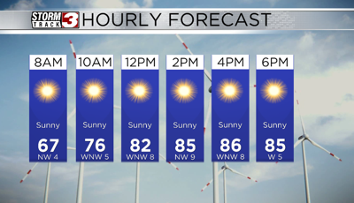
For today, we are tracking lots of sunshine for the entire day. We will see temperatures reach the lower 70s by 9AM and the low 80s by 12PM. Highs this afternoon will be in the mid to upper 80s. Dew points will be in the ow to mid 50s, so the air will feel very comfortable this afternoon.
However, these mild conditions will not last through the weekend. We will be dry through most of the evening Friday. By early Saturday morning, between 4 and 8AM, we will see a line of showers and storms track from west to east. These storms shouldn't be severe, but we could see a little lighting and heavy rain.
These storms should be out of the area by midmorning, and we may see some sunshine for the late morning and afternoon hours. This will help us warm into the mid to upper 80s.
Depending on how much the atmosphere destabilizes, we could see a few stronger storms tomorrow afternoon and evening, with the main hazards being damaging winds, small hail, and localized flooding. The best window for severe weather tomorrow will be between 6PM and 12AM.
We will see scattered showers and storms last through Sunday morning, but they shouldn't be severe. We will see dry time Sunday in the afternoon.