
January 8th Evening Weather with Meteorologist Jacie Brianne
CARTERVILLE Ill. (WSIL) -- Dangerous cold is expected overnight. Low temperatures will plummet into the single digits. It will be the coldest night of the week. There is also a chance for freezing fog, this could lead to more black ice. Slow down, especially on bridges and overpasses.
Thursday will be a mostly quiet day, with "warmer" high temperatures. Highs will rise back up near freezing during the afternoon. This is the time to finish up any errands ahead of our next winter storm. Snow will begin to move in Thursday evening and continue through Friday.

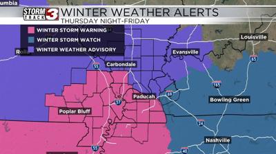
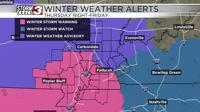
The National Weather Service has already issued several winter weather alerts for Friday's storm. A Winter Storm Warning has been issued for parts of southeast Missouri, parts of southern Illinois, parts of western Kentucky and northwest Tennessee (the pink areas). A Winter Weather Advisory is in place for parts of southern Illinois, southeast Missouri and western Kentucky (the purple areas). Caldwell and Lyon counties are also under a Winter Storm Watch.
The has been an uptick in potential snowfall amounts with the latest data. The highest impacts are still expected through the southern half of the region, where 4"-6" of snow is possible. Across the northern half of the viewing area, 2"-4" is expected. The good news is, it's looking like all snow and no ice. However, plan for a slick commute Friday morning and stay tuned for adjustments.