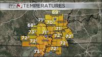
CARTERVILLE Ill. (WSIL) -- Today: Cloudy conditions with isolated to scattered showers throughout the day should be expected. Temperatures for most of us will stay chilly in the low 40s. Not expecting widespread rain at any point but you could get caught in a few showers throughout the afternoon. Make sure to bring the rain gear with you outside as you head out today.
February 5th Midday Forecast with Meteorologist Nick Boynton
Tonight: A warm front ends up moving northward overnight tonight. This will allow some moderation in temperatures (especially for our southern regions in WKY and NW Tennessee) into the 50s. While places further north across southern Illinois may stay in the 40s. Best chance for lingering showers or maybe a storm or two would be across western Kentucky and NW Tennessee.
End of the week: Thursday once again features some showers and a few storms but should be more focused across the southern half of the viewing area. Friday remains dry and cool. 40s should be the dominant temperature but a swing back into the 50s/60s may happen briefly for Saturday.