Carterville, Ill (WSIL) -- An amazing start to our work week continues for the next day or so before some changes enter our forecast. As we progress through Wednesday and Thursday we will see more in the way of a southerly flow return to our region. Isolated showers are possible, mainly south, on Wednesday and our temperatures will be warming up. Highs will be back into the mid and upper 80s and lows back into the mid 60s. Humidity will increase as well but wont be too oppressive as a cold front approaches Friday.
Friday we have the best shot at some showers and storms across the region. However models still are not too excited about the chance for widespread heavier rain amounts which we certainly need across the region. Expect drought conditions to continue to worsen across the area through the next few weeks.

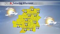
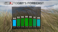
Friday's cold front will bring a substantial shift in temperatures across the area. Once it passes our first real shot at fall like temperatures hit especially overnight. Low temperatures will get into the 40s over the weekend along with high temperatures struggling to get into the mid 70s. Low humidity along with those temperatures means you need to be getting outside and enjoying this weather!