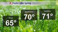
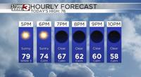
CARTERVILLE Ill. (WSIL) -- Tonight: Temperatures quite warm today in the 60s across the region. Lots of sunshine as well has aided in the spring like warmth. Warmer weather will lead to a warmer evening across the area. Temperatures will remain in the 50s and upper 40s for a majority of the evening. Eventually cooling off into the low 40s by tomorrow morning.
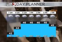
Wednesday: Clouds move back into the region as a cold front approaches from the NW. This will be a generally weak cold front. Not expecting severe weather or any sort of significant rain threat. Generally less than a half an inch of rain expected at any given location. The rain could come during the evening commute for several of us across the region. So make sure to take it slowly if you do encounter some of this rainfall.
Thursday and Friday: A beautiful end to the week is expected. That cold front doesn't drop our temperatures too much. We stay in the upper 50s and low 60s with full sunshine expected. Spring making itself known after a bitter cold mid February across our area.