
Freezing Rain Moving in Monday Morning
Carterville (WSIL) -- We stay calm and cold for the rest of the day today. By tonight we should start seeing clouds move in from the south and west.
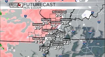
These clouds will eventually bring precipitation over the region as we head into the day on Monday morning. Any precipitation that makes it into our region before 12-3 PM has the chance to start as freezing rain and sleet. The biggest areas of concern would be along and NW of the Kentucky/Illinois border.
I would argue to say from Mt. Vernon towards Cape Girardeau down to Poplar Bluff have the best chance of seeing the most impactful ice accumulation Monday morning. The NWS is monitoring trends to see if a winter weather advisory needs to be issued. I would continue checking back in with us for the latest on any potential advisories that could come out.
Regardless, even a light glaze up to a tenth of an inch of ice could easily occur with temperatures starting out quite cold in the mid 20s as precipitation moves in. This light glaze would make travel very tricky for any areas spoken about above. Make sure if you have to travel early on Monday to give yourself plenty of extra time and take it very slowly on the roadways.
After about 2-3 PM on Monday we all switch over to a cold rain for the rest of the day. Southerly flow over the next week will provide a continued warm up into the 50s for highs as we get to Wednesday and Thursday but also continues waves of rainfall.
Expect a good soaking for the entire area of 1-3 inches by the end of the week.
Overall, icy start to your Monday but we gradually warm up throughout the entire week as we deal with a week long period of clouds and showers.