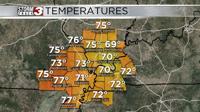

WSIL(Carterville, IL)-- This morning, most of us are waking up to temperatures that are in the lower 40s and a windchill factor in the mid 30s, due to westerly winds of 10 to 15 miles per hour.
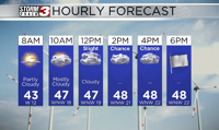
Today, you can expect to see a few breaks in the the cloud cover this morning, before becoming cloudy late this morning. We will see colder temperatures today with temperatures likely only topping out in the low to mid 40s this afternoon.
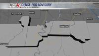
Breezier winds may make it feel a little colder as we go throughout the day. There is a wind advisory that starts at 10:00 AM and goes through 7:00 PM this evening for Pemisoct and Dunklin counties in southeastern Missouri for wind gusts that could be over 45 miles per hour.
For the rest of us, we certainly could see wind gusts over 35 miles per hour, especially this afternoon and evening.
In addition to the gusty winds, we could see a few isolated showers this afternoon and evening. Isolated showers will last through the day tomorrow, but they should be light, and not cause any substantial accumulations.
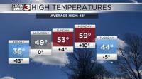
Morning lows tomorrow will likely be in the upper 30s, and highs tomorrow will likely be in the upper 40s once again.
We will remain cooler through the end of the work week with highs in the 50s for Friday. We will lose the isolated shower chances for Friday, and should not see them return until Sunday.