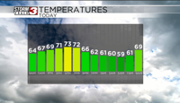


WSIL(Carterville, Ill.)-- This morning, conditions are dry and temperatures are in the low to mid 60s across much of the area, though it is a little warmer in our southernmost counties.
Today you can expect to see more clouds in the morning hours. However, we will see clearing skies first towards the south and west across southeastern Missouri by midday. Despite the cloud cover, we will not see any rain across any parts of the area. Eventually, everyone will see mostly sunny skies this afternoon after roughly 2PM.
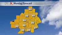
Temperatures will be in the upper 60s through the middle of the afternoon. Once we see more sunshine highs will get into the low 70s. However, where we see cloud cover decease earlier, highs could be in the mid to upper 70s (Mainly around southeastern Missouri).
Overnight, we should see mostly clear skies. However, early in the morning hours, we will see partly cloudy skies become mostly cloudy by midday tomorrow. Most of us will be dry through the first half of the day tomorrow, but in the afternoon, we will see scattered showers and storms, with one or two of them possibly turning strong to severe. The overall risk of severe weather is very low.
We will see widespread rain set in for Friday, and once all is set and done we could see 1 to 2 inches of rain on top of what has already fallen.