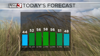
WSIL(Carterville, IL)-- This morning, we are waking up to temperatures that are pretty close to average for this time of year, with a lot of upper 30s and lower 40s.
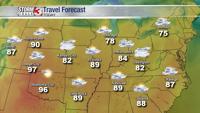
Today, you can expect to see partly cloudy skies this morning before they turn mostly cloudy this afternoon. Temperatures will warm into the low 50s by lunchtime and into the upper 50s and lower 60s for highs across southern Illinois. Highs further south in southeastern Missouri and western Kentucky could be in the mid to upper 60s. This variation in temperatures will be due to some locations seeing more cloud cover than others.
Tomorrow morning, we will see low temperatures in the mid to upper 30s. and lower 40s. We will see partly cloudy skies, with highs that could be in the upper 60s to near 70. Some locations may break 70 where we see a little less cloud cover.
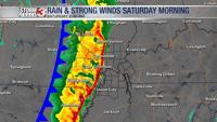
A few isolated showers are possible this evening associated with a cold front. Showers will be light and brief.
The cold front will lead to slightly cooler weather for the start of the weekend with highs in the mid 50s on Saturday; the 60s will return for Sunday.
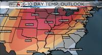
We are tracking better rain chances for Monday and Tuesday of next week.