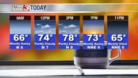


CARTERVILLE Ill. (WSIL) -- Today: Cold and mostly cloudy skies will prevail through most of the area. Temperatures once again only reaching the low 40s. Certainly feels like a winter day. By the evening thicker cloud cover will enter the region as our next system approaches.
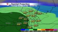
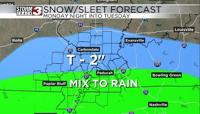
Tonight into Tuesday: Precipitation will start to creep in from the south and west late tonight into early tomorrow morning. From the Ohio river to the North is the best locations to be cold enough for snowfall. Temperatures will be generally marginal in the 32-33 degree range so not expecting too many problems on roadways. However snow could be ongoing during the morning commute which could lead to reduced visibilities. There is also a small chance isolated banding develops of heavier snow which could pose some travel issues where those bands set up. Just make sure to give yourself plenty of time if you have to get out and about Tuesday!
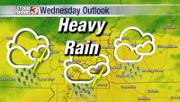
Wednesday: System number 2 rolls in but this for now looks to be a mainly rain with some ice mixed in as well. Temperatures in the atmosphere warm even though surface temps will remain in the mid 30s. This allows for mostly rain mixed with some sleet. The further north and west you go we could see more issues with icing as temperatures at the surface could be below freezing. We will monitor and keep you updated.