WSIL -- A wet morning as a band of showers tracks across the area from the west to the east. While most of the rain is light, a few heavier downpours have occasionally mixed in.
Rain will gradually shift to the south and east through the morning, leading to the return of dry time for many by the early afternoon.

A weak cold front moving in from the north could fire off a few more pop up showers or storms later this afternoon.
After sunset, pop up storms will fade quickly.
Thursday morning will be dry, but temperatures and humidity will be rising as the front lifts back to our north by the afternoon.

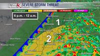
Our attention will then turn to a complex of thunderstorms tracking down the warm front across eastern Missouri. These storms will likely drop to the east and southeast. Timing is tricky as a few storms could fire as early as mid-afternoon, but the main threat is likely to be focused Thursday evening and night.

The strong storms could produce straight line wind damage, small hail, and a brief tornado or two can't be ruled out.

Following the storms, a cold front will usher in much cooler weather for Memorial Day weekend.


