

Carterville Ill. (WSIL) -- Very warm day out today but still nice overall. The heat really shows up tomorrow which is why we have a heat advisory in effect from 12PM tomorrow until 8PM. The introduction of much higher dewpoints will bring our real feel temperature back into the triple digits for many. The good news is that it will be short lived as thunderstorms are in the forecast.聽

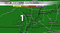
Tomorrow morning there may be a morning round of showers and storms for areas along and north of route 13 which could help in keeping the heat index in check up there (hence why there is no heat advisory yet for those areas). Most of the other portion of our forecast area will see sunlight and dry time through the afternoon which is why their heat index values will be upwards of 105-110. This will also provide instability for a secondary round of storms in the late afternoon for these areas. There is a small risk for severe storms but the threats will remain damaging wind gusts, heavy rain, and lightning.聽
Best chance for morning storms will be southern Illinois and the best chance for afternoon storms will be in south eastern Missouri. But anywhere has a chance to see storms at any point in the day tomorrow.聽
After tomorrow we will see a brief but very nice relief from the heat and active weather. Temperatures falling into the upper 80s on Sunday afternoon and even lower 80s by Monday afternoon. Monday probably the best day of the forecast due to the low temperatures and very low humidity. Definitely days you want to spend outside!