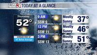


WSIL(Carterville, IL)-- This morning, we are tracking lows in the upper 20s and low 30s, with wind chill values in the mid 20s. After the cold start to the morning, we are tracking temperatures that will be in the mid to upper 30s to low 40s by mid-morning, and into the upper 40s to near 50 by lunchtime. Winds will be gusty at times today, with winds out of the south-southwest at 10 to 15 miles per hour.
This afternoon, we will warm into the low to mid 50s. Skies will be mostly sunny. However, a few more clouds will be possible in the afternoon and evening. We will be remaining dry this afternoon and evening, and winds should decrease this evening to 5-7 miles per hour.
Overnight, we will see temperatures drop into the low 40s by 9 o'clock, and into the upper 30s by midnight.
To start the morning tomorrow, we are tracking temperatures that will be in the mid to upper 30s. It is possible that a few spots could make it to the freezing mark tomorrow morning, but we are not tracking a widespread freeze. Winds will be gusty tomorrow morning, with peak wind gusts between 20 and 25 miles per hour. These gusty conditions could cause wind chill values tomorrow morning to be into the mid to upper 20s.
Highs tomorrow will be in the mid to upper 50s, to near 60 tomorrow. We will see partly cloudy skies to start the day tomorrow, and turning mostly sunny by afternoon. Clouds will return for the evening, but we are tracking dry conditions throughout the day.
As we look towards the weekend, we are tracking warmer weather and isolated rain chances for Sunday.