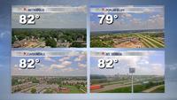


WSIL (Carterville) -- 'Fall-like' trend is continuing today as a high pressure moves in from the west. We're still seeing a few clouds stick around and temperatures are very comfortable with highs in the upper 70s, low 80s. It's a perfect day for all the Salukis that are moving in.

Into the evening hours, we'll stay in the 70s. Humidity continues to stay low making it feel even better outside. Into the overnight hours, we'll see clearing skies again and lows in the low 60s. Another great night to give the AC a break!

Tomorrow the high pressure will be off to our east, shifting our winds out of the south which will drive up humidity. A weak cold front will move through tomorrow evening bringing the isolated chance for rain. It momentarily drops our dewpoints for a day before humidity surges back this weekend.

Late this weekend and into next week a heat dome will build in driving up humidity and temperatures, feeling much more like August. Highs will climb back into the mid 90s with heat indices even warmer.