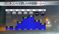


WSIL(Carterville, Ill.) -- This morning we are tracking temperatures that are mostly in the lower 20s and upper teens. However, we are seeing north-north-westerly winds at 5 to 10 miles per hour, which is making it feel like the lower teens and single digits for most locations this morning. Skies are mostly cloudy this morning.
As we go through Tuesday, temperatures are going to remain on the cold side. Temperatures will still be in the lower 20s through 9 this morning, and highs today should be in the mid to upper 20s today. However, winds will be sustained at 5 to 10 miles per hour out of the northwest, so wind chill values may only top out today in the mid to upper teens. Today you can expect to see a mix of sun and clouds all day today, and conditions will remain mostly dry other than a few flurries or light snow showers.
Overnight, we will see partly cloudy skies. Temperatures will fall rapidly overnight, likely into the lower teens and single digits by early tomorrow morning. We are also tracking winds that will be out of the north and west at 5 to 10 miles per hour. This may make it feel between 0 and 5 degrees below zero across southern Illinois. Temperatures tomorrow will once again only reach the mid 20s for high temperatures tomorrow afternoon, with wind chills only reaching the mid teens. Skies will be mostly sunny.
For Thursday, mostly sunny skies will last through most of the day. Morning lows will be in the lower teens and single digits with sub-zero wind chills, with high temperatures that will reach the upper 20s and lower 30s. Cloud cover will build back into the region overnight Thursday into Friday, out ahead of our next storm system. For Friday, we are tracking the chance of scattered to widespread snow showers. Thankfully, temperatures will be cold enough to support an all snow event, and we likely will not see any mixing. However, it is still uncertain how much mixture will be in the atmosphere, and the amount of moisture will determine how heavy snow will be be and how much we will get.