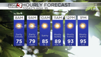


WSIL(Carterville, Ill.)-- This morning, skies are partly cloudy, and temperatures are running well above normal; most of us are seeing lows in the upper 60s and lower 70s.
Dangerous heat is expected once again later today. As early as 10AM, we could see temperatures reach the upper 80s and lower 90s. Highs today will once again be in the upper 90s and lower 100s for a few of us. The hottest temperatures today should be in our easternmost counties.
Skies today will be partly cloudy for most of us. We will remain dry today, and mostly clear through the overnight hours.
For Friday, we are tracking morning lows that should be in the mid 70s for most of us, and highs should be slightly cooler than they have been over the last few days; likely in the mid 90s.
For the commute tomorrow morning, thing should remain dry, but after the lunchtime hour, we will see a few isolated storms form with the heating of the day.
Better rain chances are expected later in the evening and overnight hours Friday night into Saturday as a cold front approaches the region. The front could slow down as it passes over the area, so we could see shower chances linger though the day on Saturday.
Once the front clears the area, we will see mostly sunny skies for Sunday and Monday. High will be in the upper 80s for Sunday, but for Monday, we will see highs in the lower 80s. Dew points will be in the 50s, so it will feel very comfortable for Labor Day.
Comfortable weather should last through most of the week next week, but high will slowly return to average by Wednesday.