

CARTERVILLE (WSIL) -- It was soggy day across the region, with cool temperatures. More rain is moving in from the south, primarily for northwest Tennessee and western Kentucky. Most of southern Illinois and southeast Missouri will remain dry. Any lingering showers will move east, out of the area, around midnight.
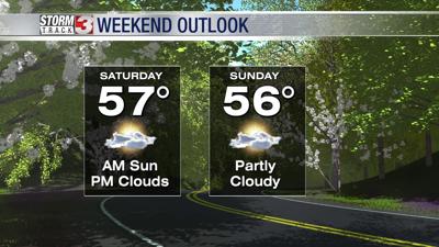
This weekend will be chilly. High temperatures will dip back well below average both Saturday and Sunday. Highs will only rise into the mid to upper 50s, with a mix of sun and clouds. Winds will also be breezy Saturday, out of the northwest, gusting near 25 mph.
If you've started your spring planting, keep an eye on low temperatures. Sunday and Monday morning, lows drop into the low to mid 30s. Patchy frost is likely, which could damage sensitive vegetation.
Slightly warmer temperatures return next week, but stay below average, in the 60s.