

WSIL (Carterville, IL)-- This morning, we are tracking temperatures are once again very warm for all of us this morning. This morning we are tracking a dense fog advisory that includes far southeastern . This is for reduced visibility that could be at or below a quarter mile Missouri and northwestern Tennessee. This is for reduced visibility of a quarter mile or less, and the advisory lasts through 10 this morning. Though most of the area isn't included in the dense fog advisory, there still could be isolated patches of dense fog.
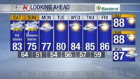
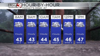
Today, you can expect to see cloudy skies with dry conditions. Temperatures will be in the upper 40s for highs, and a few stray possible late this afternoon.
Tomorrow, we will see this wide spread rain through the morning hours, with the heaviest rainfall occurring in the late morning and early afternoon hours. We will see light rain last through the afternoon hours. Highs tomorrow will be in the low to mid 40s.
A few isolated showers are possible early Sunday morning, but the bulk of the rain will be over by Sunday morning. Skies will be mostly cloudy on Sunday, but we will see a lot of dry time. Highs Sunday will be in the low to mid 40s once again.
For the start of the work, we are tracking dry conditions and well above average temperatures.