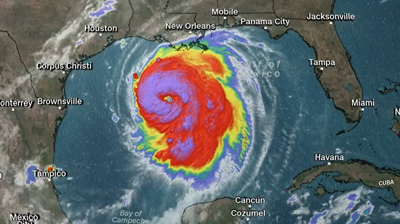

GALVESTON, Texas -- The National Hurricane Center says Hurricane Laura has become "an extremely dangerous Category 4 hurricane" packing 140 mph winds, clocked by an Air Force hurricane hunter airplane flying into the storm.
Laura is expected to strike Wednesday night into Thursday morning somewhere along the Louisiana-Texas border. Forecasters warn of "catastrophic storm surge, extreme winds and flash flooding."
Laura's well-formed eye was 200 miles (320 kilometers) south southeast of Lake Charles, Louisiana and Port Arthur, Texas, early Wednesday afternoon, traveling northwest at 16 mph (26 kph).
Tropical storm winds reached the coast of Louisiana Wednesday afternoon.
An observing site at Eugene Island measured sustained winds of 39 mph (63 kph) and a gust to 64 mph (104 kph).
Forecasters expect up to 20 feet (6 meters) of storm surge.
They predict Laura will reach at least 145 mph (233 kph) winds, but may weaken ever so slightly before landfall.
The Associated Press