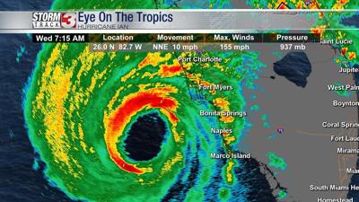


FLORIDA (WSIL) -- Hurricane Ian strengthened early Wednesday morning to a strong Category 4 storm with maximum sustained winds of 155 miles per hour. That's just shy of Category 5 strength.
At 7 a.m. Wednesday, the eye wall was roughly 30 miles off the coast of Naples, Florida, tracking to the north/northeast at around 9 miles per hour.
The current forecast projects landfall around midday Wednesday along the western coast of Florida between Fort Myers and Sarasota.
Storm surge will be highest on the southeast corner of the hurricane's eye, projected to top 12 feet near from Punta Gorda south to Cape Coral.
In addition to destructive flooding along the coast, tremendous amounts of rain are expected inland with some areas possibly receiving more than 15 inches through Thursday.