


WSIL(Carterville, IL)-- Today, we are tracking temperatures that will be slightly warmer than they were yesterday with highs in the mid 80s. This afternoon, we will see a slight increase in humidity as the high pressure system tracks off to the east.

We are tracking a weak cold front that will be moving though the region this afternoon, which will bring an isolated chance of a shower this afternoon. The greatest chance of an isolated shower is further to the north. Shower chances will decrease as the weak cold front moves towards the south.
Behind the front, we are tracking slightly cooler temperatures for Friday with highs returning to the lower 80s.

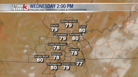
But, these mild conditions will not last long, as we are tracking hot temperatures starting Saturday with highs in the mid to upper 80s, and continuing through late next week. At this time, Monday, Tuesday, and Wednesday are expected to be the hottest with highs in the mid to upper 90s.

In terms of rainfall, we are not tracking any chances of rain for next week at this time.