


CARTERVILLE, Ill. (WSIL) -- The weekend isn't at hot as what it was on Friday, but the heat isn't the only reason to be aware. We are tracking showers and storms later this afternoon and evening.

A Heat Advisory remains in effect for all counties in the region until 7 this evening.
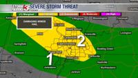
A Severe Thunderstorm Watch remains in effect for Madison County in southeast Missouri until 7 this evening. We are monitoring the potential for other counties in our region to go under a new watch. There remains some uncertainty behind the timing of a cold front moving through.

Saturday: Afternoon highs into the upper 80's and lower 90's will eventually drop back into the lower 70's. A few showers and storms are expected to the late afternoon and evening hours. A few storms could be strong to severe. The primary threats are damaging wind gusts, heavy rain and even the potential for some small hail. The SPC has our region outlined in a Level 2 out of 5. This upgrade comes as the potential for damaging winds is heightened.
Sunday: The SPC has outlined portions of SEMO and WKY and WTN into a Level 1 out of 5 for the early morning chance of damaging winds with any lingering storms.
Morning lows will be into the lower to mid 70's with afternoon highs forecast to reach the upper 80's to lower 90's. A cooler day compared to Friday and Saturday. Winds from the NW will add a slight "breeze". We will continue to see rather cloudy conditions. The heat index will not be as high as dew points are forecast to be into the mid and upper 60's. A few isolated showers and storms will be possible through the afternoon hours.
Monday: Morning lows into the mid and upper 60's with afternoon highs forecast to reach the upper 80's and lower 90's. Partly cloudy becoming mostly cloudy with a chance of isolated to scattered showers and storms in the late afternoon.
Through the rest of the week it seems daytime highs don't change too much, staying into the upper 80's and lower 90's. A few more chances of showers and storms will remain.