

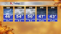

WSIL -- It's not as cold this morning and frost is not much of a concern as temperatures are above freezing in the mid to upper 30s.

A lot of sunshine to start the day will be covered up by clouds by midday as a weak cold front drops in from the north. Despite light winds turning back to the north, temperatures will still warm into the mid to upper 50s.
There's a small chance for a shower or two early Wednesday morning, but as sunshine returns by the afternoon, highs will bounce into the lower 60s.

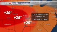
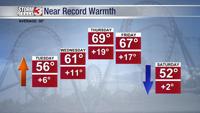
Near record warm temperatures are possible by Thursday and Friday. Thursday is likely to be the warmest day with highs near 70º. The record high in Carbondale is 71º set back in 1982.