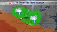
CARTERVILLE, Ill. (WSIL) -- Some rain has moved through our area this afternoon with more rain chances later this evening.
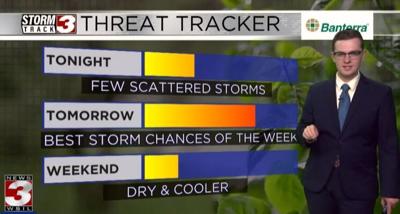
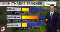
Tonight we are expecting more clouds to move in with rain chances continuing through the night hours. Winds will also be relatively low at around 5 mph. Temperatures will stay into the 70s until around 9 p.m. where we will start dipping into the 60s.
Overnight, we will see more of the same. Temperatures in the mid 60s with pockets of rain moving through.
When you wake up on Friday morning, rain chances will continue. We have a higher chance for rain throughout the day. A thunderstorm or two can't be ruled out though. Some may see some pretty good downpours at times. Temps will top out in the mid 70s. Just make sure you have your umbrella ready.
On Saturday, we will have some pretty amazing weather. We will start off in the upper 50s and slowly climb into the mid 60s by the afternoon hours. Winds will be up to around 10 mph and you should start seeing the sun at times with the partly cloudy conditions.
On Sunday, more of the same fabulous weather. We should some mostly cloudy conditions, however, the temperatures should be in the mid to high 60s and it should feel pretty comfortable outside for some yardwork. Although, there is a slim chance for some rain.
Next week, we will see 80s as highs for Monday and Tuesday with showers and potential thunderstorms to follow.