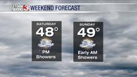

CARTERVILLE, Ill. (WSIL) �� More thunderstorms are forecasted to move through our region this evening.
A tornado watch has been issued until 11 p.m. for all of western Kentucky, northwest Tennessee and Pemiscot County, Missouri.
A few tornadoes are possible with hail up to 2 inches in size is also possible. Wind gusts up to 70 mph are also possible with these storms.
Tonight: After the sun sets tonight, temperatures will dip into the lower 50s and rain chances will dissipate by midnight. However, cloudy conditions remain and winds will start to calm.
Monday: Clouds will move out and we will be waking up to clear skies for most of the area. This will be short lived as clouds will start coming back into the area by late morning. After waking up to temps in the lower 40s, they will soon make it into the 60s by midday. Winds will also pick back up.
Looking ahead: It will be 60s as highs for most of the week. The next chance for thunderstorms and rain looks to be on Friday.