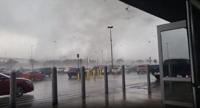
WSIL -- A Tornado Watch is in effect for parts of southern Illinois, southeast Missouri, western Kentucky, and northwest Tennessee until 11 a.m.

A Flood Watch is also in effect for entire region until 12 a.m. Wednesday morning.
Strong storms are possible, especially this morning in areas south of Route 13. The main threat is strong straight line winds, but a brief spin-up tornado can't entirely be ruled out.
The flooding threat is significant where storms track over the same areas multiple times. The heaviest rain is likely to set up across the Missouri Bootheel and western Kentucky where 2-4" of rain is possible.
By this afternoon, storms will mainly be confined to areas along the Kentucky/Tennessee line.
A strong cold front will sweep across the region this evening, ushering in much colder air overnight.

Our attention then turns to a potential winter storm Wednesday night and Thursday. Freezing rain and sleet is likely to overspread the region Wednesday evening, becoming widespread into Thursday. Ice is most likely in southern Illinois and southeast Missouri, and rain is more likely in western Kentucky.