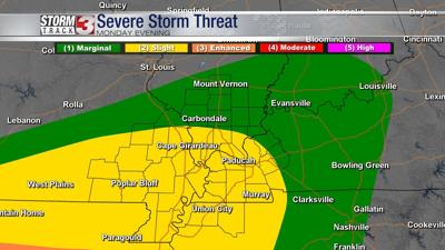


CARTERVILLE, IL (WSIL) -- Monday evening storms will continue to fire up.
Temperatures will drop into the lower 50's with a mostly cloudy and rainy evening.
Tuesdays high is forecast to be into the lower to upper 60's with an overnight low into the 50's.
Isolated thunderstorms are possible into the evening hours, becoming more widespread into the early morning hours of Wednesday.
By Wednesday, the Storm Track 3 Team is tracking a very active day of weather with all severe modes possible.
Temperatures will be into the lower to mid 70's with thundershowers lingering around from the overnight hours.
By afternoon and into the evening hours strong to severe storms capable of damaging winds, hail, and even tornadoes will be moving through.
Download the Storm Track 3 App for any watches and warnings in your area.