


WSIL(Carterville, Ill.) -- This morning, we ae tracking temperatures that have stayed very warm last night, thanks to an increase in cloud cover, as well as southerly winds at 15 to 25 miles per hour.聽
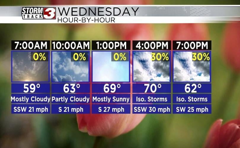
Winds today will be out of the south at 20 to 30 miles per hour, and this afternoon, gusts could potentially be as high as 40 to 50 miles per hour. For this reason, there is a Wind Advisory in place from 8 this morning until 8 this evening. Temperatures today will be warm, reaching the low to mid 60s by lunchtime, and highs today will reach the low to mid 70s. Cloudy skies will be will be with us through the morning hours, but partly cloudy skies are expected this afternoon.聽

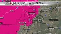
Once we see the sun come out, conditions at the surface will dry out in terms of the amount of moisture. This will create dangerously low relative humidity. This, combined with the warm temperatures, and very strong winds will create an elevated fire risk tomorrow afternoon. This risk is particularly high, so a Red Flag Warning has been issued from 11 AM tomorrow morning until 8 PM tomorrow evening.聽
There is also a chance of a few isolated thunderstorms tomorrow between 12 PM and 6 PM. But, the best chance for these storms will be along and east of interstate 57. One or two of them could be on the strong to severe side, but this chance is very low, as there is very limited moisture.聽
A cold front will sweep through the region in the afternoon and evening. This will cause temperatures to drop very quickly, with morning lows expected to only be in the mid 30s for Thursday. Highs Thursday will be in the mid 50s, so the fist day of spring will feel more like winter unfortunately.聽