

WSIL(Carterville, Ill.) -- This evening, we are tracking showers that are impacting our northern counties across Jefferson and Hamilton county. We are seeing a few reports of lightning and thunder, but no severe weather is expected.
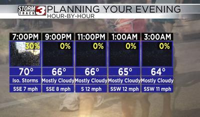
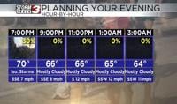
This evening, we are going to continue to see isolated showers and storms continue through 8 or 9 this evening. Shower and thunderstorms are expected to remain highly concentrated to southern Illinois, so if you do have any Thursday evening plans, make sure to pack an umbrella. Temperatures this evening are also very warm, with most places reporting the upper 70s to lower 80s. Temperatures for the rest of the evening will remain warm.
By 7 or 8, temperatures are still expected to be in the low 70s, adn overnight tonight, temperatures are not expected to dip below 60 degrees. Skies south of state route 13 will be mostly clear with partly to mostly cloudy skies expected north. This will hep temperatures overnight remain in the lower 60s, even as we are kicking off the day tomorrow. Despite the cloud cover, not rain is expected.
Temperatures tomorrow afternoon will be very warm, likely once again in the upper 70s to lower 80s. Skies tomorrow will be partly to mostly cloudy, with winds that will be out of the south-southwest at 10 to 15 miles per hour.
Another round of isolated showers and thunderstorms is possible tomorrow afternoon and evening after 5 PM, but widespread rain and storms are expected for Saturday and Sunday. Strong to severe storms are possible for Sunday afternoon, with all hazards possible.