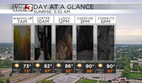


WSIL(Carterville, Ill.)-- This morning, all of us are waking up to temperatures that are warm and muggy! Most of us are seeing temperatures in the lower 70s. We are also seeing a few isolated showers. But, these showers will dissipate by 8:00 or 9:00 this morning.
We will see a little cloud cover linger through late this morning and into the early afternoon, but sunny skies are expected by 1 or 2 this afternoon.
Today, you can expect to see temperatures warm into the upper 80s and low 90s for highs. We will likely see the heat index get into the upper 90s, and possibly the low 100s in a few isolated spots.
For the weekend, we will see temperatures on Saturday start out in the 60s and 70s for most of us. Highs will be in the low to mid 90s tomorrow, with heat index values slightly lower in the mid to upper 90s.
Sunday, the heat will continue highs expected to be in the mid to upper 90s with heat index values expected to be in the low 100s for most locations.
We will be dry this weekend with mostly sunny skies. Early next week, we will see a lot of heat and sunshine. We will also have isolated chances for showers and storms Monday through Wednesday.