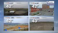
As we go through most of the day, we will see temperatures reach the mid 80s by lunchtime, and the upper 80s and lower 90s for afternoon highs. Skies today will be mostly sunny though most of the afternoon.
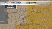
There is a Lake Wind Advisory in effect from 10 AM this morning through 6 PM this afternoon. This is because winds could be sustained at 10 to 15 miles per hour, with gusts as high as 30 miles per hour.
These breezier winds are associated with our next storm system which will start to impact the area late this evening, mainly after 9 PM this evening. Overnight tonight, we will see a line of showers and storms track from northwest to southeast. There is a very low chance that a few of these could be strong to sever. If they do get to severe limits the main hazards would be damaging winds and small hail.
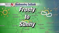
Storms should exit the region in time for your Wednesday morning commute and we will get some dry time in the mid morning and early afternoon hours before storms reform for the afternoon and evening.
For these storms, there is a level 2 out of 5 risk for severe weather across southern Illinois, western Kentucky, and northern southeastern Missouri. There is a level 3 risk for far southeastern Missouri. Hazards with any severe storms tomorrow will be damaging winds, large hail, and a brief tornado.
One thing that may reduce the potential for severe weather is that we may not have the instability present. Its something we will be watching closely.
Highs tomorrow will be in the mid to upper 70s. We will see rain chances every day between now and Sunday.