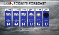


Carterville (WSIL) -- Happy Easter! Another incredibly warm day out there and staying dry. The clouds have increased noticeably vs. yesterday but a stiff southerly wind has kept our temperatures in the 70s today.
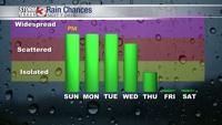
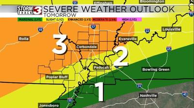
Our eyes quickly turn to Monday evening as the Storm Prediction Center has put par of our region under a level 3 risk for severe weather. A few clusters of thunderstorms are expected to move through the area late Monday evening through the overnight period. The main threat with these storms will be damaging straight line winds but a quick spin up tornado cant be ruled out in a few of these lines. Hail is also a threat but since these storms roll through overnight the hail isn't the biggest threat.
The system as a whole has been slowing down a bit so there is potential we see some storm linger into Tuesday morning and afternoon especially in our SE areas like Paducah.
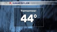
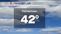
After the system moves out temperatures will drop throughout the day on Tuesday getting us feeling like winter for your Midweek.