

After last nights round of thunderstorms we remained very overcast today and will remain that way over the next several days.
Much cooler today with highs barely reaching 50 degrees in many areas and temperatures will continue to cool as we head towards early next week.
Some rainfall trying to spread into the area today but a dry airmass in place is keeping much of the rain confined to our south. I do expect some rainfall to make its way into extreme NW sections of Tennessee later this evening but the rain will be fairly light.
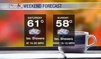
Sunday will remain cloudy and cool with temps in the upper 40s and low 50s for all. We should stay dry for your Sunday before our next weather maker on Monday.
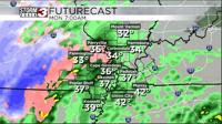
Monday features an upper level low moving over our area which initially will mean a cold rain for us all. But as we head later into the day the precipitation will generally get heavier and that will allow temperatures to cool further to allow some snowfall to mix in. For now I don't expect many travel disruptions as we will be above freezing for the event. If anything maybe some grassy accumulations but little road impacts.
It will be a nice reminder that we are still in the heart of winter!