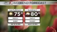


Carterville (WSIL) -- Spring is officially right around the corner and a wonderful day today with full sunshine reminds us of that. Stiff NW flow kept our temperatures generally cooler though in the low to mid 50s across the entire area. Another cool but clear night is on tap with many of us dropping once again into the low 30s with some patchy frost as you wake up tomorrow.
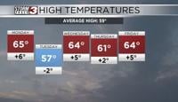
Monday and Tuesday feature more sunshine with our winds shifting from the NW to the SW bringing in much warmer air for both days. Expect highs topping out in the mid to upper 60s for both days with partly cloudy skies. These are by far the best days of the week so be sure to go out and enjoy them if you can!

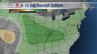
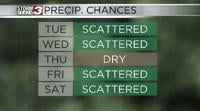
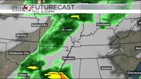
An increase in southerly flow also means an increase in moisture so expect those rain chances and cloud cover to increase as we head towards the ladder half of the week. At this point not looking at any washouts but definitely scattered bouts of showers and storms.